ThruHiking Across Grand Teton National Park in Wyoming

The Teton Range sunset from the East, WY - Photo Credit: Nicole Quinn
Enjoy another edition of our Trip Report series! In honor of this Wednesday being the birthday of the National Parks System, this one focuses on a thru-hike through Grand Teton National Park. If you've gone on an epic backpacking trip recently and want to tell our readers about it, we'd love to feature you on a guest blog! E-mail blog@pathloom.com for more info.
Trip Info:
Trip Type: Thru-Hiking
Season: August 2020 (Summer) - Note: impassible conditions at least until late July due to snow. Check with a backcountry ranger before starting and especially if attempting this hike before early August.
Location: Grand Teton National Park, WY
Total Distance: 41 miles
Elevation Gain: 8,061’ ascent, -7,576’ descent, (average grade: 8%, max grade: 34%)
Duration: 4 days / 3 nights
Trail Type: Point-to-Point (One-Way)
Direction: South to North
Permit: Required for optimal route; however, it is possible to string this hike together without permits - this involves staying in National Forests/Wilderness areas along the way, and hiking significantly more mileage each day.

Overview:
The Teton Crest Trail is a difficult/strenuous backpacking trip with mostly moderate to steep terrain. A truly world-famous backpacking/thru-hiking trip that you’ll find on most ‘best of’ lists for the continental U.S., this trip is as good as it gets.
Since most of this hike is in high alpine terrain (>8,000 feet), you’ll want to be sure you get acclimated to the elevation before beginning your hike. Generally, 4-5 days of increasing activity (depending on your fitness level) should be enough to get you ready for the elevated terrain.
Additionally, the alpine terrain can make for unpredictable weather - so be sure to check in with a backcountry ranger before you begin for the latest forecast, and avoid any exposed areas if you see ominous clouds rolling in. With high-alpine terrain comes a short hiking season - due to snow, you likely won’t be able to safely attempt this hike outside of a short window between early August and mid September.
There are tons of ways to tackle this epic hike, ranging from 35-45 miles depending exactly where you start your journey - and with numerous itinerary options as well. This trip guide will cover what I believe to be the best itinerary, a 4 day/3 night trip beginning at the Teton Village Ski Resort and ending at the Leigh Lake/String Lake Trailhead. Enjoy the guide!
FYI, well over 90% of this particular itinerary is within the boundaries of Grand Teton National Park. if you do the entire trail, which would add about 15 miles to this trip, it would mean you’d likely start outside the park and work your way in.

Grand Tetons, WY - Photo Credit: Sierra Jones
Trip Planning:
Permits:
Permits are required for hiking the Teton Crest Trail and all other backcountry camping in Grand Teton National Park. Due to the competitive permitting process, be sure to apply WELL in advance. The reserve-ahead permit process begins the first Wednesday in January, and runs until May 15 each year. When I was planning for this hike, I went to book permits for my group of four at the exact minute they went live. While we got two of our three top choices, the process was so competitive that we had to settle for one sub-optimal location as our preferred destination filled immediately. You can’t really go wrong with any of the sites along the trail, but I definitely recommend being ready to bounce right away for the best shot at the perfect itinerary. Smaller groups (6 people or less) must pay a $35 permit fee while groups of 7-12 will be required to pay a $45 non-refundable processing fee in addition to the base fee.
Camping:
Groups of 1 to 6 people are welcome at any camping zones along the trail, while groups of 7 to 12 people must camp in designated group campsites. Zones are marked with a sign on each end, and hikers with a valid permit are free to choose where they wish to camp once arriving at the zone.

Grand Tetons, WY - Photo Credit: Scott Carnahan
Itinerary:
Day 1: Teton Village → Death Canyon Shelf
Drive to the Teton Village ski area, and park your car in the Ranch Lot. If you are parked overnight for multiple nights in any of the other lots, you will be ticketed or towed. To make this first day much more manageable (and cut out roughly 5 mi and 2,700 ft. of elevation gain), take the aerial tram to the top of Rendezvous Mountain and begin hiking from there. When I did this hike for the first time, the aerial tram was closed for the season for maintenance. As a result, we took the ski area’s Bridger Gondola and climbed the Cirque trail to the top of the peak instead. This was a long, hot, climb that made the first day very challenging when it was all said and done.
Take a second to take in the Rendezous Mountain summit, boasting some of the most rugged and famous resort skiing in the entire world come wintertime - as well as panoramic views of Jackson, Grand Teton, and beyond. Once you’ve soaked it all in, head down the gravel service road for about a half mile to pick up your trail, and head out for the remainder of a long, hard, day hiking.

Aerial Tram - Photo Credit: Jackson Hole Resort
Hike through beautiful alpine meadows (prime bear country, be bear aware!) as you find more and more peace and solitude with each passing mile.
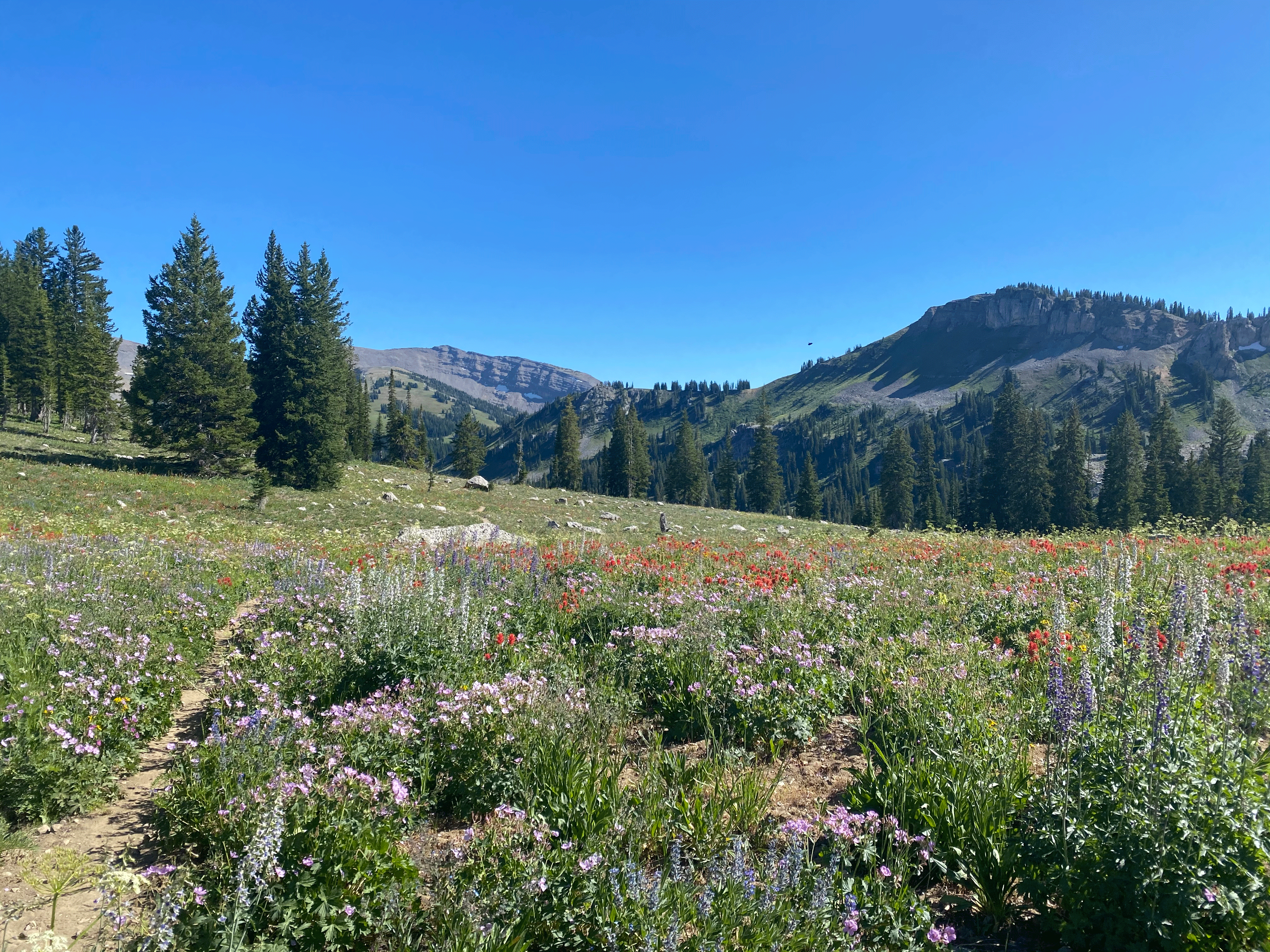
Wildflower Filled Meadow - Photo Credit: Ryan French
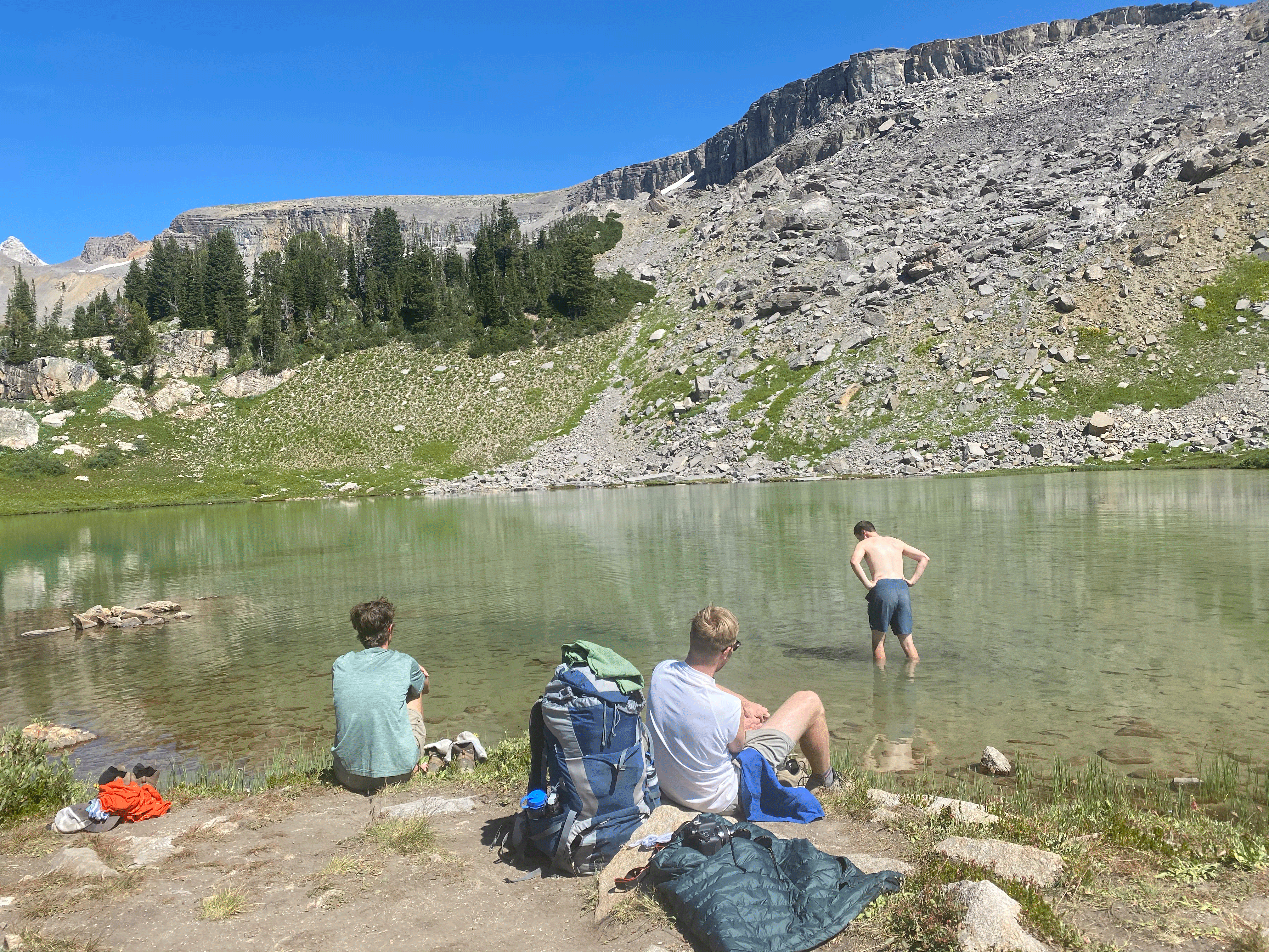
About two-thirds of your way through the first day (7 miles in), you’ll encounter Marion Lake - the first of many picturesque alpine lakes along this world-famous route. The south side of the lake offers a deep swimming area under the shadow of a dramatic cliff face - take a dip if you can handle the cold!

Marion Lake - Photo Credit: Nicole Quinn
After you relax for a while at the lake, you’ll start a steep climb to a ridgeline to hike your final few miles of the day. With stunning views of Grand Teton towering in the distance, the vast plains of Idaho to the West and the jagged peaks of the Gros Ventre Mountains to the East - if you’re anything like me, you’ll find yourself unable to keep a smile off your face despite the grueling mileage you’ve already logged. When you reach the Death Canyon Shelf junction, head left (up the ridgeline to the North), up another final ascent before reaching your camping zone. Find yourself a spot that has clearly been camped in before and relax for the evening!
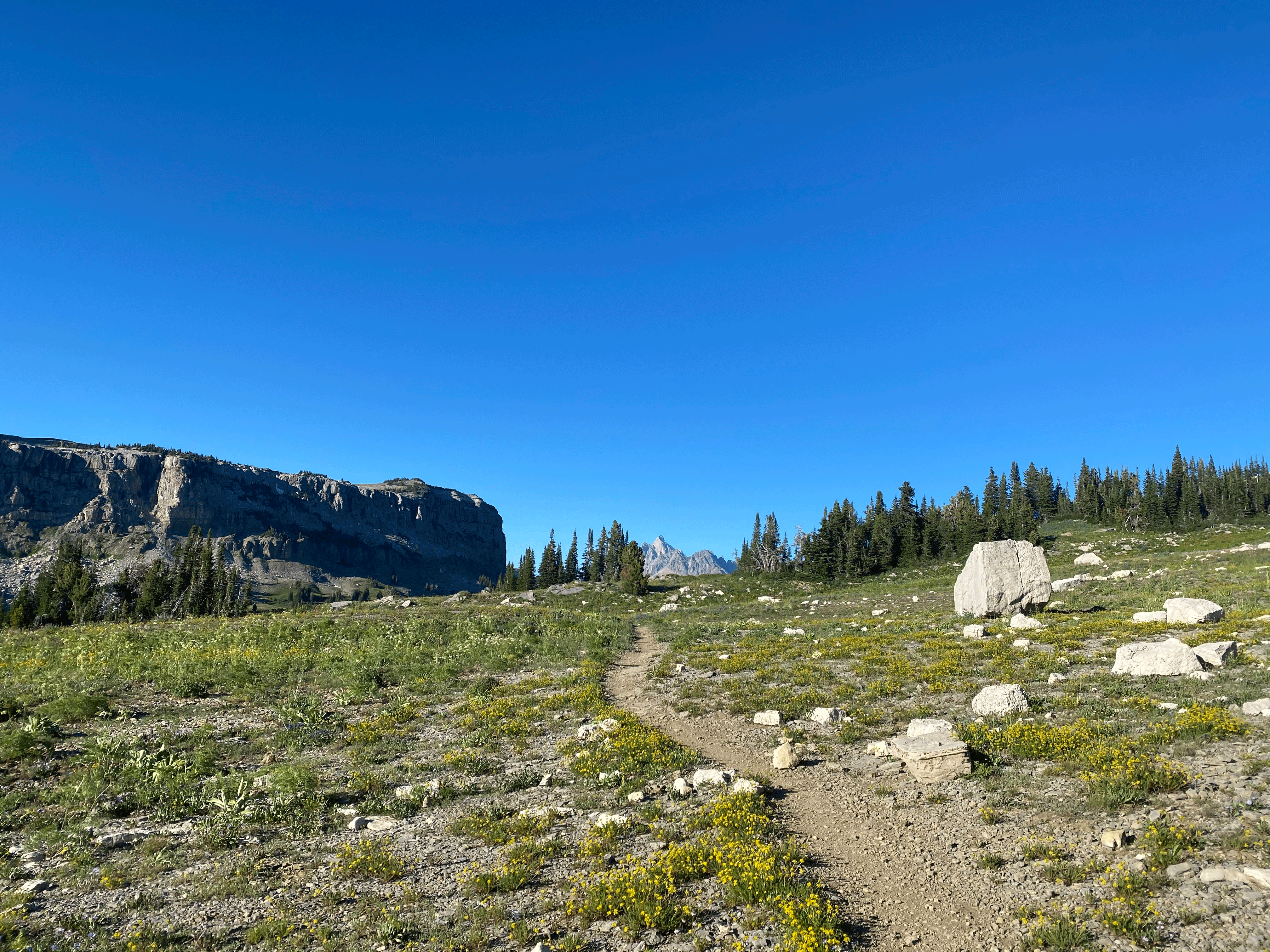
Grand Teton looming in the distance along the Teton Crest Trail - Photo Credit: Brett Stanton
Note: This was the one campsite that did not work exactly according to plan for myself and our group. We were forced to head down to the Death Canyon camping zone - this was perfectly fine on the surface, but required us to make a steep descent at the end of our day to reach the site, only to then have to ascend directly back on that same trail the next morning to resume our hike. If at ALL possible, avoid this zone and opt for the Death Canyon Shelf (if you’re planning to follow the 4 day/3 night itinerary) so you’re not forced to backtrack!
Total Distance: 9-12 miles (depending how far you venture into the camping zone)
Day 2: Death Canyon Shelf → South Fork Cascade Canyon
Another great day of hiking awaits when you wake up at the Shelf! You’ll start the day hiking along the shelf with epic views of The Canyon below - all with Grand Teton off in the distance as a vantage point. This was a dramatic sight, because you’ll actually end up with Grand Teton behind you to the South by the end of the day! Water can be scarce for the first half of this day, so it might be wise to top off if you do encounter a running stream during the early portion of Day 2.
After a few miles of rolling hills, you’ll descend over about 3 miles into the Alaska Basin. This area is National Forest Land, so we met several people along the way who had decided to camp here due to their inability to secure National Park Permits. Alaska Basin is a truly beautiful oasis, with a powerful running stream and beautiful shaded enclaves for lunch, surrounded on all sides by dramatic rock formations.

Entering Alaska Basin - Photo Credit: Andrew Helmbrecht
After you take in the Basin, you’ll start your first major ascent of the day - this time to Sunrise Lake.
Stopping to rest in Sunrise Lake, Photo Credit: Nicole Quinn
This is another great swimming spot with sweeping panoramic views. You’ll want to take a breather here - you’ve got a mammoth climb up steep mountain switchbacks to reach 10,400 feet of elevation atop Hurricane Pass. This ascent was one of those “I hate hiking why am I doing this” moments - but you’re quickly reminded exactly why you’re out there once you reach the top. A truly unique view of the Teton range and beautiful turquoise runoff basin lake - both of which a miniscule fraction of the park’s visitors ever get the pleasure to see - await you. Take pictures and appreciate how far you’ve come!
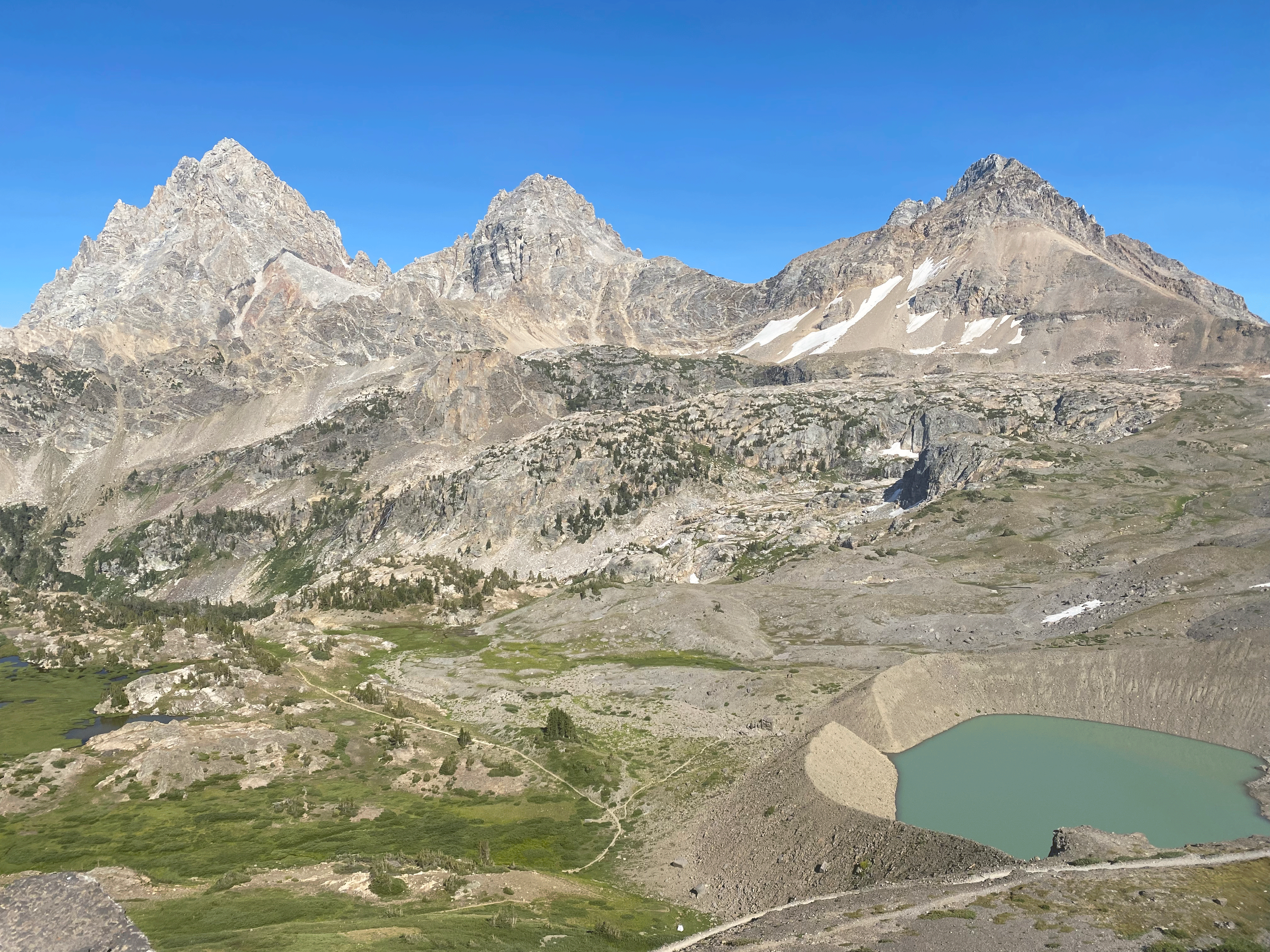
View of Grand Teton and the Teton Range from Hurricane Pass, Photo Credit: Nicole Quinn
You’ve got about 2 miles to descend off Hurricane Pass before you reach your second night’s destination. This was my favorite camping zone of our hike - many of the sites immediately upon entering the camping zone sit on elevated rock croppings separated by classic alpine meadows and various little creeks. You’ll feel like you and your group have a little suite to yourself once you pick your rocky outcropping. We used one to sleep at and one for cooking and going to the bathroom. On the way between our two private ‘villas’ we encountered a mountain goat mother and her kid and stopped to watch them for nearly an hour under the setting sun - hard to beat a moment like that!
Total Distance: 9 miles

Sunset in the South Fork of Cascade Canyon - Photo Credit: Andrew Helmbrecht
Day 3: South Fork Cascade Canyon → Holly Lake
A very challenging, picturesque, and heavily trafficked day awaits when you wake up on day 3. After hiking out the South Fork of Cascade Canyon, you’ll turn Northwest toward one of the crown jewels of the entire hike (and quite possibly the most beautiful alpine lake I’ve ever set my eyes on) - Lake Solitude. Ascend 2.7 miles (and don’t forget to turn around periodically for yet another epic vantage point of Grand Teton) along a suddenly heavily trafficked trail to arrive at Lake Solitude.

View of Grand Teton & Teton Range approaching Lake Solitude - Photo Credit: Nicole Quinn
Since this is a popular 1-night overnight or even day hiking destination, you’ll see more people than you’ve seen in days. However, if you’re up and out early from your campsite in the South Fork, you should have no problem beating the crowds.
You’d be remiss to not take an (ice cold) dip in Lake Solitude during lunch - and your body will need the ice bath to prepare for what is to come: the grueling ascent to the high-point of the trail: 10,700 foot Paintbrush Divide.

Lake Solitude - Photo Credit: Nicole Quinn
As we sat at the lake trying to trace the trail up the dramatic rock bowl we knew we had to summit, we couldn’t envision any possible path - and you’ll surely have another “Holy $%#@” moment once you finally muster up the courage and energy to tackle the climb.
About 80% of the way to the top of The Divide, you’ll see the trail open up into what feels like the crest. Unfortunately, you still have a ways to go before reaching The Divide’s summit, but you can feel motivated knowing this is the final climb of your hike… it’s all downhill the rest of the way when you reach the top! The top of The Divide again offers panoramic views, and the colorful geology for which the Paintbrush Divide gets its name. Take another break here - you’ve got the most exposed and nerve-racking section of the trail to tackle before you’re smooth sailing down to your third night’s site.

The view from Paintbrush Divide - Photo Credit: Andrew Helmbrecht
The descent from Paintbrush traveling North involves covering the same elevation change in about a third of the distance - meaning you’ll face severely steep, narrow, and exposed edges on your way down. Our group was very heights-tolerant, but this piece of the trail would be extremely challenging to manage if you have a severe fear of edges. However, we made it down the steep section, across a snow field that was still very much a challenge even in late August, and down to Holly Lake unscathed. Sigh of relief! Settle in at this gem of a lake and rest easy knowing you’ve got just over 6 miles straight down hill between a shower and a hot meal!
Total Distance: 10 miles
Day 4: Holly Lake → Leigh Lake/String Lake Trailhead
The final day is here! You’ll likely wake up feeling sore but refreshed - this is it! Deep into day 3, I remember feeling so relieved to be nearing the end of the hike, but when I woke on day 4 I was quite bummed to be heading out of the backcountry on that day… I felt revived and like I was just getting started! Again, this is a popular day-hiking area, so you likely won’t enjoy the same solitude you did earlier in your journey. On your way out, be sure to spend some time on the shores of Leigh Lake - it is a beautiful destination in its own right! The descent from Holly Lake is 6.1 miles to the Leigh Lake/String Lake trailhead, where we had arranged a ride to shuttle us back to Teton Village for about $100. Alternatively, if you have multiple cars in your group, you can park one at each end of the trail. When you get back to Teton Village - I highly recommend a meal at the Mangy Moose. Nothing like some delicious pub food when you’ve been eating granola bars and ramen for days on end!

Dark and Stormy Tetons, WY - Photo Credit: Scott Carnahan
Gear List (With Links):
Backpack & Storage:
Backpack: Osprey Aether 55L Pack
Backpack Rain Cover: Osprey Ultralight Raincover
Fanny Pack: Trailmix Plus Insulated Hydration Belt
Dry/Stuff Sacks: Osprey Ultralight Dry Sack
Bear Canister (Required; Can rent from NPS for free w/ a security deposit if needed): Backpacker’s Cache Bear-Resistant Container
Hiking:
Gaiters: Black Diamond Talus Gaiter
Mask: Face Mask with Vent
Shelter:
Tent with Rainfly: NEMO Ultralight 2-Person Backpacking Tent (Shared)
Tent Footprint: NEMO Dragonfly Footprint
Sleep System:
Sleeping Bag: Patagonia 850 Down Sleeping Bag (No Longer Made)
Sleeping Pad: NEMO Tensor Alpine Mummy Insulated Sleeping Pad
Camp Kitchen:
Fuel: MSR Fuel (Isopropane)
Cookpot: Stanley 24oz Kettle
Lighter: BIC Lighter
Cup: Sea to Summit X Cup
Food:
Breakfast: Quaker Instant Oatmeal, and Green Tea
Snacks: Clif Bars, Honey Stinger Waffles, Fritos
Electrolyte/Energy Refreshment: Honey Organic Stinger Energy Chews
Dinner: Ramen, Pasta, Summer Sausage, Mac n Cheese
Hydration:
Purification/Taste Neutralization Tablets: Potable Aqua Iodine and Potable Aqua Plus
(Note - I would recommend a more robust water filtration system for a hike of this length, this was one of the more tedious parts of the entire trip. A successful hydration system that our Founder and CEO, Ankit, uses, which I’ll plan to try on future trips is below:)
Clean Water Bag: Platypus Big Zip EVO Reservoir (3.0L)
Dirty Water Bottle: LIFEWTR 1L
Clothing:
Rain Pants: Outdoor Research Helium Rain Pants
Rain Jacket: Patagonia Calcite Jacket
Jacket: Patagonia Nano Puff Jacket
Tools, Electronics and Miscellaneous:
Headlamp: Vont LED Headlamp
Phone: Apple iPhone 11 Pro Max
Power Bank: Solar Power Bank
Watch: Garmin Instinct GPS Watch
Hygiene:
Emergency/First Aid:
We hope you enjoyed another edition of our Trip Report series! In honor of this Wednesday being the birthday of the National Parks System, this one focuses on a thru-hike through Grand Teton National Park. If you've gone on an epic backpacking trip recently and want to tell our readers about it, we'd love to feature you on a guest blog! E-mail blog@pathloom.com for more info.
Disclaimer: This post may contain affiliate links. In exchange for referring sales, we may receive a small commission to help us keep the lights on here at Pathloom. This comes at no extra cost to you.
Check out these other articles by Pathloom which you may enjoy:
Sign up on our website for exclusive early access to the Pathloom BETA app, and let us help you plan your next outdoor trip! As an early user, you will receive exclusive access to our BETA app, outdoor guides, and information - created solely for you by Pathloom!
Sign up today and we will send you a list of our favorite dispersed camping places in California!
Pathloom is a Bay Area-based technology startup on a mission to get more people outdoors, more often by reimagining the way people discover the outdoors.
