How to Get Eastern Sierra Backpacking Permits
- Luna DeLamer

- Aug 1, 2025
- 6 min read
It starts innocently enough. You open Insta and there’s some hiker posed next to a turquoise lake in the Eastern Sierra, sun glinting off their trekking poles, grinning like they didn’t just poop in a cathole. You decide this is the year. You’re gonna backpack the Sierra. Maybe hit Big Pine Lakes, maybe suffer through Kearsarge, or if you’re feeling bold (read: delusional), maybe even bag Mount Whitney.
You load up Recreation.gov, enter your dates, pick your trailhead, click “Search Availability,” and…
Nada.
“No availability for selected date.”
“No availability.”
“No availability.”
And that’s the moment you realize getting an Eastern Sierra backpacking permit is harder than the actual hike.
But don’t worry, friend. I’ve screamed into the digital void so you don’t have to. This guide will walk you through how to actually snag Eastern Sierra backpacking permits, avoid the classic permit mistakes, and (mostly) keep your sanity intact.
We'll cover when to apply, which Eastern Sierra trailheads matter, how Inyo National Forest permits work, how to use Rec.gov Eastern Sierra listings without rage-quitting, and where to sleep once you get out there. It's all here, shall we have a gander?

What Area is the Eastern Sierra In?
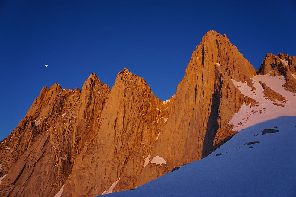
Okay, so let’s clear this up. The Eastern Sierra isn’t its own park or forest. It’s a massive, glorious chunk of the Sierra Nevada mountain range that runs along the eastern edge of California. Highway 395 runs from Lone Pine in the south up through Bishop, Mammoth Lakes, and Bridgeport in the north.
This is where the granite gets dramatic. Tall, spiky, glacially carved, jaw-on-the-dirt kind of dramatic.
Most backpacking routes in this region fall inside Inyo National Forest, which also overlaps with wilderness areas like:
John Muir Wilderness
Ansel Adams Wilderness
Golden Trout Wilderness
Hoover Wilderness (up north near Virginia Lakes and Yosemite’s back door)
So when we talk about Eastern Sierra backpacking permits, what we really mean is…If you want to go play in Inyo’s backyard, you’re going to need their permission slip.
Whether you’re going for a mellow overnighter to Duck Lake, a JMT section hike, or a summit push for Whitney, you’re going to be applying through Recreation.gov for an Inyo National Forest wilderness permit.
Got that? Great. Because now comes the hard part, actually bagging that permit.
When to Start Planning Your Trip
(And How to Score Shoulder Season or Last-Minute Spots Without Crying)
Here’s the brutal truth: if you’re trying to hike between late June and mid-September, you better start planning six months in advance. No exceptions.
Permits for Inyo National Forest drop exactly 6 months (182 days) ahead of your entry date at 7:00 a.m. Pacific Time on Recreation.gov. Not 7:01. Not “whenever I finish my coffee.” 7:00:00.
You’ll be competing with every other hiker who also wants a shot at Bishop Pass, Cottonwood Lakes, or the Whitney Portal trail.
Pathloom Tip
If your dream route is full, try checking for:
Mid-week entries
Less popular trailheads like Pine Creek or Taboose
Shoulder season dates in late September or even October
What If You Miss the Permit Drop?
Don't worry, 40% of permits are held back and released exactly 2 weeks before your entry date at the same ungodly hour (7:00 a.m. PT). These are known as “walk-up” permits, but guess what? They’re online now. No actual walking involved except back to your laptop to refresh, refresh, refresh. There are some exceptions, but regardless, it is advised to check online.
And yes, cancellations go live instantly, so even if it's 3 days before your trip, it's worth checking. People cancel all the time… injuries, weather, breakups, existential crises. One hiker’s meltdown could be your miracle.

Research the Trails to Find Which Permits You Need While Backpacking Through the Eastern Sierra
Here’s where a lot of first-timers get wrecked: not all Eastern Sierra backpacking permits are created equal. It’s not just “get one permit and wander wherever your heart and knees take you.” Nope. In the eyes of Inyo National Forest, your permit is trailhead-specific, date-specific, and yes, even group-size specific.
How Permits Work
Your entry trailhead defines your entire trip.
Want to start at Kearsarge Pass? Your permit is tied to that trailhead on that day with that group size.
Planning to hike out via Whitney Portal? Surprise! You might need a separate exit permit or to enter the dreaded Whitney Zone (which has its own quota and fee).
Example Time
Let’s say you want to do a loop starting at Cottonwood Lakes, heading up over New Army Pass, then exiting via Whitney Portal after tagging Mount Whitney.
That sounds incredible… but it means:
You need a Cottonwood Lakes permit for entry
You’ll need to select an itinerary that passes through the Whitney Zone
And you’ll pay the $15 per person Mount Whitney fee on top of your regular reservation fee
Now, if you don’t enter the Whitney Zone, no extra permit required. But the minute you set foot in it? That’s it. Game on. (Recreation.gov Eastern Sierra listings will ask you to select “Exit via Whitney Portal” as an option; don’t skip it if it applies.)
Best Eastern Sierra Backpacking Routes & Where They Start
Here’s a quick hit list of popular trails and their Recreation.gov listed trailheads to make life easier:
Route | Trailhead (Permit Name) | Wilderness Area |
Big Pine Lakes | Big Pine North Fork | John Muir Wilderness |
Bishop Pass to Dusy Basin | South Lake/Bishop Pass | John Muir Wilderness |
Cottonwood Lakes Loop | Cottonwood Lakes | Golden Trout Wilderness |
Kearsarge to Rae Lakes Loop | Onion Valley/Kearsarge Pass | Kings Canyon + John Muir |
Duck Lake | Duck Pass Trailhead | Ansel Adams Wilderness |
Pine Creek to Italy Pass | Pine Creek Trailhead | John Muir Wilderness |
Mount Whitney (overnight) | Whitney Portal (Overnight) | Whitney Zone |
If you’re stringing together a thru-hike like doing part of the JMT or connecting to the PCT, just make sure your entry permit matches where you start, and check if you pass through any zones (ahem, Whitney) that need extras.
How to Apply for the Required Permits for Backpacking Through the Eastern Sierra
(AKA How to Survive Recreation.gov Without Rage-Punching Your Monitor)
Here we go: the digital Thunderdome.
To get your Inyo National Forest permits, you’ll need to visit Recreation.gov, the Forest Service’s blessed/cursed portal for everything from backpacking permits to campsite bookings to battlefield tours (no joke).
Step-by-Step Permit Process:
Create a Recreation.gov account ahead of time. Don’t wait until 6:59 a.m. to set your password.
Go to the Inyo National Forest Wilderness Permits page.
Choose Overnight – Excluding Mt. Whitney or Overnight – Mt. Whitney depending on your trailhead.
Plug in your:
Entry trailhead
Start date
Group size
Trip duration
Add exit zones like “Whitney Portal” if applicable.
If there’s availability (fingers crossed), add it to cart and check out FAST.
You’ll pay:
$6 reservation fee (non-refundable)
$5 per person OR $15 per person if entering Whitney Zone
Print that sucker out no more than 7 days before your trip. Sign it. Carry it with you. Rangers do check.
❌ Don’t assume “I'll just grab it on the trail.” You will get fined. And publicly shamed. Maybe even on Reddit.
Where Can You Camp in the Eastern Sierras?
Now that you’ve locked in your permit, time to find your campsite: somewhere between 10,000 feet and a complete lack of Wi-Fi.
The good news? Backcountry camping in the Eastern Sierra is mostly wide open as long as you follow Leave No Trace and wilderness regulations. That means:
Camp at least 100 feet from water (even if it’s SO PRETTY)
No fires above 10,000 feet (so basically, bring that stove)
Dig your cat hole at least 6 inches deep and 200 feet from water
Respect all posted signs, some alpine lakes have designated zones or no-camping rules to protect fragile ecosystems
If you're heading to a popular spot like Big Pine Lakes, Thousand Island Lake, or Guitar Lake, you’re not the first to have this idea. Expect other tents, and maybe a ranger swing-by. But otherwise? You’re free to choose your own adventure as long as your permit’s valid and you respect LNT.

Is There an Easier Way to Get Permits for Backpacking the Eastern Sierras?
(Kinda. But Not Really.)
Look, Recreation.gov is the only official source for these permits. There’s no secret backdoor. No sketchy Reddit workaround. But you can work the system smartly:
Aim for less competitive trailheads (Taboose, Pine Creek, Duck Pass)
Try shoulder season trips: late September to early October means fewer humans, more solitude
Keep your group small, permits go fast for groups of 6–8, but solo/duo groups have better odds
Refresh like a gremlin during the 2-week walk-up drop
And if you're a risk-tolerant explorer with a flexible schedule? Some people do gamble and go without a permit, hoping for a same-day walk-up at a ranger station. But that’s a whole other game, and I’m not endorsing it unless you really like uncertainty.
Final Scoop
Look, backpacking in the Eastern Sierra is worth every spreadsheet, every 6:00 a.m. alarm, and every profanity hurled at Recreation.gov. This place is ridiculous, in the best way. Crystalline lakes, otherworldly peaks, alpenglow mornings that make you feel like you’re in some epic fantasy movie.
But to experience it right, you need to nail your Eastern Sierra backpacking permit, and that takes some strategy. Plan early. Know your trailheads. Understand how Inyo National Forest permits and Whitney Zone rules work. Use those Recreation.gov Eastern Sierra listings like a pro. And once you're out there?
Just breathe it in. Eat the cold-soaked couscous. Watch the Milky Way do its thing.
You earned this.